| General | product name | SA130 |
| dimensions | 164*102*138.3 mm | |
| weight | 2 kg | |
| supported aircraft | SOUTH SF1200/SF3300/SF4200 Matrice 300 RTK/350 RTK |
|
| working temperature | -20℃~+55℃ | |
| IP | IP64 | |
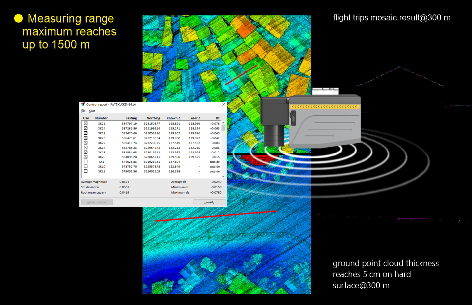
| System Performance | system accuracy | 5 cm@300 m (Horizontal/Vertical) |
| storage | 256 G Flash Drive Disk | |
| control mode | auto control by Ground control station or remote control by Laptop/ Mobile phone APP | |
| LiDAR | laser scanner | 400 scan-line |
| principle | pulse | |
| maximum measuring range | 1500 m | |
| minimum detection range | 1 m | |
| measuring accuracy | 15 mm(single)/ 5 mm(repeat) | |
| measurement rate | max.2000,000 points/s | |
| scanning FOV | 100° | |
| laser safety class | Class 1 (IEC 60825-1: 2014) eye-safe | |
| angular resolution | 0.001° | |
| laser wavelength | 1550 nm | |
| echo | multi-echo | |
| Inertial Navigation System | posture | Roll/Pitch: 0.006°,Yaw: 0.019° |
| positioning accuracy | horizontal: 0.01 m; vertical: 0.02 m | |
| IMU Update Frequency | 500 Hz | |
| RGB Mapping Camera | resolution | 45 MP |
| focal length | 18 mm | |
| sensor size | 36*24 mm(8192*5460) | |
| pixel size | 4.4 μm | |
| photo format | JPEG | |
| video format | MP4 | |
| Data collection software(GCS) | Fly2MAP Pilot | |
| Trajectory processing software | AcuteLas Studio software | |
| LiDAR data post-processing software | AcuteLas Studio software |
South Precision - Copyright 2019. Developed by Web Multi Design