Job Time: Nov 2020
Job Location: Guangzhou, China
Area Size: 0.08 sq.km
Job Target: 1:1000 topography
Accuracy Expectation: elevation 10 cm
Output Demand: point cloud, DEM, contours
Challenge: inaccessible, hilly terrain

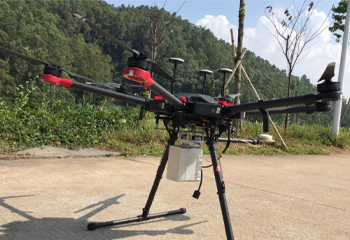
Survey Solution: Hexacopter Matrice600 Pro + Z-Lab LiDAR-eco
Number of Flight: 3 flights
Take-off Point: 2 spots
Flight Altitude: approx. 80 m for each flight
Flight Duration: 36 minutes in total
Number of Checkpoint: 70 points by GNSS RTK measurement

Fieldwork:almost 1 day (lots of time invested in terrain analysis and take-off point selection)
Processing: 3 days
Output 1: geo-referenced point cloud

Output 2: DEM

Output 3: Contours
