

CHINA SATELLITE NAVIGATION EXPO
On November 23, the 11th China Satellite Navigation Conference (CSNC) and China Satellite Navigation Expo (CSNE) was held in Chengdu, Sichuan province. Founded in 2010, CSNE is the largest, most influential and authoritative professional exhibition in the field of satellite navigation in the world. With the theme of “Satellite Navigation: A...
Read more
SOUTH NEW TECHNOLOGIES GLISTEN IN ZHENGZHOU
On October 28, the 2020 Academic Annual Meeting of the Chinese Society for Geodesy Photogrammetry and Cartography was held in Zhengzhou, Henan. The 10th China Surveying and Mapping Geographic Information Technology and Equipment Expo held at the same time is an influential event in survey industry. The world-renowned survey...
Read more
A WONDERFUL APPEARANCE OF SOUTH SMART AT THE 2020 CHINA GIS CONFERENCE
2020 China Geographic Information Society Conference opened in Nanning International Convention and Exhibition Center on Oct. 23. This conference with a geographic information society achievement exhibition. South Smart, a subsidiary of South Group, made its debut with the latest technological achievements and multi-industry application solutions, sharing scientific and technological...
Read more
OPMMS-3D LASER INTELLIGENT SLOPE MONITORING SYSTEM
In recent years, this technology has been widely used in the field of monitoring, and slope monitoring is a typical example. Whether it is highways, railways, bridges or open-pit mines, or even many natural disasters, slope monitoring is required. At present, the traditional monitoring technology not only has many...
Read more
CHINTERGEO 2020
On September 25, the CHINTERGEO 2020 with the theme of “Goes hand in hand, goes upstream” was held in Qingdao, Shandong province, China. More than 200 enterprises participated in the exhibition. This exhibition is the first national event for the surveying and mapping geographic information industry after the epidemic....
Read more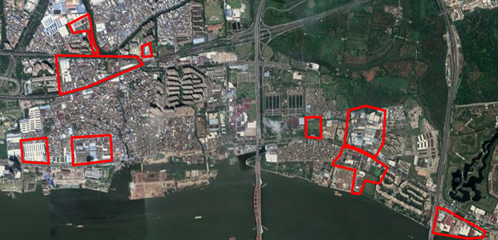
LiDAR Survey for Urban Village Reconstruction
Background Information Project Locatiion: Guangzhou, China Purpuse: Provide reference for the reconstruction and planning for Urban village Area: 0.75 sq.km (9 blocks) Output demand: 1) DOM 2) Vectorized map (1:500) Expected accuracy: H.20cm V.10cm Project time: 1 month Overview of Survey area: The houses are dense, the distance between the buildings is narrow, the visibility...
Read more
SOUTH NEW R20 EDM, NOT ONLY LONGER DISTANCE
South has released New R20 EDM. Let us instroduce its new technology and outstanding performance. Advantages: more longer, higher accuracy, less data jump, more stable and more faster. With the R20 EDM, we can measure the target with distance 2000m away in Non prism mode. This is the world...
Read more
BEIDOU SERVES GLOBALLY
China launches the last satellite of the Beidou Navigation Satellite System from the Xichang Satellite Launch Center in Southwest China’s Sichuan province, June 23, 2020. The lunch of the final satellite to complete the third-generation network of China’s Beidou Navigation Satellite System, marking a new milestone in the nation’s space endeavors....
Read more
SOUTH MONITORING SYSTEM – SMOS
What is SMOS? SMOS is SOUTH professional deformation monitoring system, it is based on the monitoring sensors, data transmission link and the data monitoring process and analysis center. The SMOS is compatible with multiple monitoring sensors like GNSS, strain stress sensor, reinforced cable monitor, vibration monitor and environment monitor...
Read moreRecent News


SMART MONITORING SOLUTION FOR DAM OF WOHUSHAN RESERVOIR

LIVE BROADCAST|VISIT ONLINE EXHIBITION WITH Mr.Ma

Recent Comments