
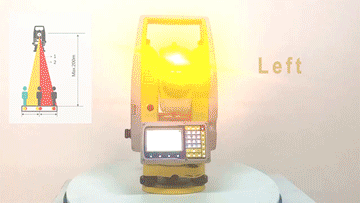
GUIDE LIGHT —– GUIDE YOUR SURVEYING
In nowadays surveying work, how do you do staking out job fast? Still use an interphone? No, you are really out of time. Having a look for SOUTH N3 total station, with a new “GUIDE LIIGHT” function, you can stake out faster than before! Let’s see what is GUIDE LIGHT...
Read more
1+X CERTIFICATE EMPOWERING SURVEYING TALENT TRAINING
In June, 2021, 124 students from 31 colleges and universities participated in the 1+X Certificate Test at Kunming Metallurgy College in Yunnan province, which was organized by SOUTH Surveying and Mapping. This is the first online application of SOUTH Test System since SOUTH has been approved the qualification of...
Read more
UAV AUTONOMOUS SYSTEM: FAREWELL PILOTS! 100% UNMANNED
“Lack of professional UAV pilots for aerial jobs? Wan to check site conditions real-time but stay indoors? Hard to arrange timely missions in case of emergency? Expect to make decisions and send commands in no time? Such are common headaches to the organizations that demand UAV applications in the...
Read more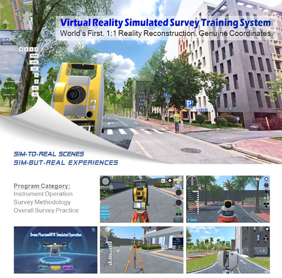
NEW MAKES SENSE. EXPLORE AND FIND YOUR NEW SOLUTIONS!
The pandemic has been an absolute disaster to many fields, including our geo-spatial industry. Aperiodic lockdown and social distancing keep most schooling and meeting off. How to continue survey class teaching and user operation training? Now, VR Simulated Survey Training System provides an ideal solution to such headaches. This...
Read more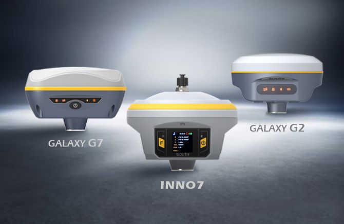
NEW MODULE, MORE SATELLITES
The BDS-3 navigation satellites system has been completed for one year. Now SOUTH has released new GNSS products to fully support BDS-3 constellation, here are some improvements on the new products: Tracking more satellites We tested the new SoC GNSS board receiver in Guangzhou, China. The receiver tracks more...
Read more
SOUTH ANDROID FIELD COLLECTION SOFTWARE SURVSTAR RELEASED
SOUTH new generation Android measurement software is perfectly compatible with the functions of the new generation RTK receiver, realizing one-key switching of working modes and quickly configuring the receiver. Support a variety of data collection modes, embedded powerful CAD engine, compatible with .dxf and .dwg format base maps, and...
Read more
SHIJIAZHUANG CITY C-GRADE LEVELING NETWORK PROJECT
According to the actual needs of social development, Shijiazhuang City Natural Resources and Planning Bureau decided to carry out the “Shijiazhuang City Basic Control Network Construction” project. The main content is to re-establish Shijiazhuang City’s B-grade GNSS control network based on the original control network points, and establish the...
Read more
CHINASKILLS JOIN HANDS WITH SOUTH
During 25-28 June, 2021 National Competition for Skills of Vocational Education Engineering Survey Event was held in Kunming, Yunnan province. 32 teams of Polytechnic College from all over the country attended here. This Competition is organized by 32 departments including the Ministry of Education, the National Development and Reform...
Read more
CHINA SATELLITE NAVIGATION EXPO OPENS IN NANCHANG
The 12th China Satellite Navigation Conference and China Satellite Navigation Expo (CSNE2021) opened on May 26 to 28 in Nanchang, Jiangxi province. With the theme of “Empowering the future with spatiotemporal data”, this expo aims to promote the deep integration of satellite navigation and 5G, artificial intelligence, Internet, big...
Read moreRecent News


SMART MONITORING SOLUTION FOR DAM OF WOHUSHAN RESERVOIR

LIVE BROADCAST|VISIT ONLINE EXHIBITION WITH Mr.Ma

Recent Comments