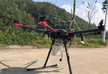
RURAL ROADWAY DEVELOPMENT TOPOGRAPHY WITH LiDAR SURVEY
Job Time: Nov 2020Job Location: Guangzhou, ChinaArea Size: 0.08 sq.kmJob Target: 1:1000 topographyAccuracy Expectation: elevation 10 cmOutput Demand: point cloud, DEM, contoursChallenge: inaccessible, hilly terrain Survey Solution: Hexacopter Matrice600 Pro + Z-Lab LiDAR-eco Number of Flight: 3 flights Take-off Point: 2 spotsFlight Altitude: approx. 80 m for each flightFlight Duration: 36 minutes in totalNumber of Checkpoint: 70 points by GNSS RTK measurement Fieldwork:almost 1 day (lots of time invested in terrain analysis and take-off point...
Read more
CHINA SATELLITE NAVIGATION EXPO
On November 23, the 11th China Satellite Navigation Conference (CSNC) and China Satellite Navigation Expo (CSNE) was held in Chengdu, Sichuan province. Founded in 2010, CSNE is the largest, most influential and authoritative professional exhibition in the field of satellite navigation in the world. With the theme of “Satellite Navigation: A...
Read moreRecent News


SMART MONITORING SOLUTION FOR DAM OF WOHUSHAN RESERVOIR

LIVE BROADCAST|VISIT ONLINE EXHIBITION WITH Mr.Ma

Recent Comments