
- HD large 5inch touch screen which fulfill the Android users needs
- New design appearance and very comfortable to hold
- Quad-Core 1.3GHz processor
- Micro-USB port and OTG function
- Being equipped with laser centering component improving the accuracy
- More sensors are installed, electronic compass, gravity sensor, Built-in thermometer, atmospheric pressure altimeter,etc.
| System | Operating system | Android 5.1/6.0 |
| CPU | Octa-Core 1.5GHz | |
| Memory | 3GB RAM, 32GB ROM | |
| Storage | up to 128G extensible | |
| GNSS performance | Channels | 220 |
| GPS | L1 | |
| GLONASS | L1 | |
| BDS | B1 | |
| GALILEO | – | |
| SBAS | – | |
| QZSS | – | |
| Data output | NEMA-0183 | |
| I/O protocol | RTCM2.3 (1, 3, 9), RTCM31 | |
| Update rate | 1Hz | |
| Reacquisition | < 1s | |
| Warm start | – | |
| Cold start | < 30s | |
| Accuracy | Single positioning | 2.5m |
| SBAS positioning | Horizontal: 0.50m Vertical: 0.85m |
|
| DGNSS | Horizontal: 0.25m + 1ppm Vertical: 0.50m + 1ppm |
|
| RTK(baseline<30km) | – | |
| Multimedia | Camera | 8.0 megapixel AF, flashlight |
| Display | 5.0 inch capacitive screen, 1280 × 720 | |
| Sensor | Electronic compass, gravity sensor, built-in thermometer, atmospheric pressure altimeter, light sensor and distance sensor (optional) | |
| Other function | Laser centering, external antenna port, integrated speakers and microphone | |
| Extended function(optional) | – | |
| Communication | network | LTE 4G modem |
| Bluetooth | BT4.0 downward compatible to BT2.1 + EDR | |
| WIFI | IEEE 802.11 b/g/n | |
| USB | Micro USB, support charging and OTG function | |
| Electrical | Battery | 3.7V, 7200mAh Li-Ion, 2 batteries (standard) |
| Battery life | Single battery > 10 hrs | |
| Battery charging | 2 stands charger, 4 hrs fast charging | |
| Environment | Waterproof/Dustproof | IP67 |
| Shockproof | 1.5m | |
| Humidity | – | |
| Operating temperature | – | |
| Storage temperature | -40℃ ~ 80℃ | |
| Physical | Dimension | 231mm(L) × 92mm(W) × 57mm(H) |
| Weight | 0.56kg (battery included) |
Features
X5 adopts professional GPS module, 220 channels, GPS, GLONASS and BDS tracking, ensure faster satellite tracking and more reliable positioning result. As one of the best sold product of South Group, X5 can be widely used in the variety GIS field. For example, forestry investigation, agriculture management, land resource investigation, underground pipe and cable detection, geodetic control survey, etc.
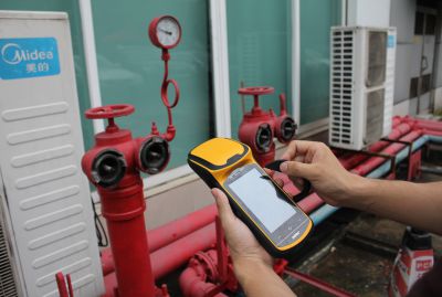
The Polar X5 handheld is from the South Polar X series family of integrated, rugged, and high-accuracy GNSS handhelds. As a streamlined solution that enables faster and more productive data collection, the Polar X5 is ideal for organizations, such as utility companies, municipalities, and environmental agencies, requiring mobile data collection and asset management solutions.
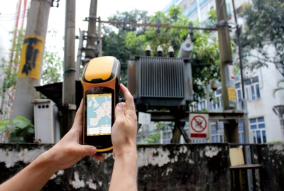
Perfect for asset management and data maintenance projects, everything is integrated into a convenient, rugged package: high sensitivity GNSS, Windows Embedded Handheld operating system or Android operating system, Office applications, camera, and cellular connectivity.
South Precision - Copyright 2019. Developed by Web Multi Design