
- New design appearance and very comfortableto hold
- HD large 5inch touch screen fulfilling the Android users needs
- Quad-Core 1.5GHz processor
- Multiple sensors and more extended functions
- Micro-USB port and OTG function
| System | Operating system | Android 5.1 |
| CPU | Octa-Core 1.5GHz | |
| Memory | 3GB RAM, 32GB ROM | |
| Storage | up to 128G extensible | |
| GNSS performance | Channels | 72 |
| GPS | L1, BD1 | |
| GLONASS | L1 (optional) | |
| BDS | B1 | |
| GALILEO | – | |
| SBAS | – | |
| QZSS | – | |
| Data output | NEMA-0183 | |
| I/O protocol | RTCM2.3 (1,3,9), RTCM31 | |
| Update rate | 1Hz | |
| Reacquisition | <1s | |
| Warm start | – | |
| Cold start | <30s | |
| Accuracy | Single positioning | 5m |
| SBAS positioning | 2 ~ 5m | |
| DGNSS | 1 ~ 3m | |
| RTK(baseline<30km) | – | |
| Multimedia | Camera | 8.0 megapixel AF, flashlight |
| Display | 5.0 inch capacitive screen, 1280 × 720 | |
| Sensor | Electronic compass, gravity sensor, built-in thermometer, atmospheric pressure altimeter, light sensor and distance sensor (optional) | |
| Other function | Integrated speakers and microphone | |
| Extended function(optional) | Scanning head, NFC, backtalk, Fingerprint identification | |
| Communication | network | WCDMA 3G modem |
| Bluetooth | BT4.0 downward compatible to BT2.1 + EDR | |
| WIFI | IEEE 802.11 b/g/n | |
| USB | Micro USB, support charging and OTG function | |
| Electrical | Battery | 3.7V, 4200mAh Li-Ion, 2 batteries (standard) |
| Battery life | Single battery > 10 hrs | |
| Battery charging | 2 stands charger, 4 hrs fast charging | |
| Environment | Waterproof/Dustproof | IP67 |
| Shockproof | 1.5m | |
| Humidity | – | |
| Operating temperature | – | |
| Storage temperature | -40℃ ~ 80℃ | |
| Physical | Dimension | 156mm(L) × 85mm(W) × 29mm(H) |
| Weight | 0.32kg (battery included) |
Features
Professional GIS Collector
The new generation hand-held GPS polar X series, Android 5.1 OS installed, applied Octa-Core 1.5GHz processor inside. Integrating multiple sensors which is very useful in the field work.
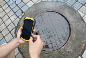
X2 handheld is a durable, compact GIS collector with an integrated high-yield GPS receiver, ideal for asset management and inspection applications. It is the latest addition to the X series family of GPS handhelds from South, providing an affordable platform to arm an entire mobile workforce with a reliable and accurate professional GPS handheld incorporating the Windows Embedded Handheld OS/Android OS. X2 adopts professional GPS module, 72 channels, GPS, BDS and BGLONASS(optional) tracking, ensure faster satellite tracking and more reliable positioning result. Compatible with GIS oriented workflows, X2 is the smart solution you can trust for standardizing inspections and asset management.
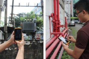
It may look like a smartphone, but X2 is all business. Rugged cover meets the need of filed work. It has a large screen so you can easily view data or photos even in direct sunlight.
You can be confident that your teams have a real, professional tool — built to work in even the tough conditions.
South Precision - Copyright 2019. Developed by Web Multi Design